Photography, Australian Landscape Photography, Panoramic Photos, |
|
Photography, Australian Landscape Photography, Panoramic Photos, |
|
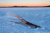 |
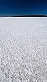
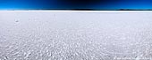
| Lake Gairdner at Sunrise AU-SA-LAKE-GAIRDNER-0001 |
 |
| Lake Gairdner at Sunrise AU-SA-LAKE-GAIRDNER-0002 |
 |
| Lake Gairdner at Sunrise AU-SA-LAKE-GAIRDNER-0003 |
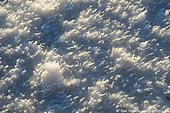 |
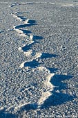
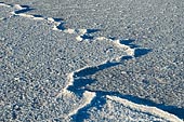
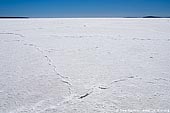
| Salt Crust on Lake Gairdner AU-SA-LAKE-GAIRDNER-0004 |
 |
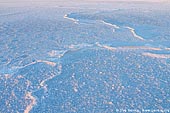
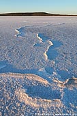
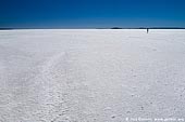
| Lake Gairdner AU-SA-LAKE-GAIRDNER-0005 |
 |
| Lake Gairdner AU-SA-LAKE-GAIRDNER-0006 |
 |
| Lake Gairdner AU-SA-LAKE-GAIRDNER-0007 |
 |
| Lake Gairdner AU-SA-LAKE-GAIRDNER-0008 |
 |
| Lake Gairdner AU-SA-LAKE-GAIRDNER-0009 |
 |
| Lake Gairdner AU-SA-LAKE-GAIRDNER-0010 |
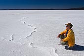 |
| Woman is Observing the Lake Gairdner AU-SA-LAKE-GAIRDNER-0011 |
The Gawler Ranges are spectacular wilderness area in Outback South Australia. Located in the north of Eyre Peninsula about 550 kms north-west of Adelaide, this is the perfect destination to explore more stunning Outback scenery and experience 4WD adventures. The entire region north of the Eyre Highway is very remote Outback country. The Gawler Ranges National Park covers 163 500 ha reserve, and is 40 km north of Wudinna, 40 km north-east of Minnipa and is accessible using two wheel drive vehicles via the gravel roads from Kimba, Wudinna or Minnipa. The ranges were formed by volcanic activity more than 1500 million years ago is around every corner in Gawler Ranges National Park. The highest point of the ranges is Nukey Bluff at 465 m above sea level. The Gawler craton is a craton rich in mineral resources, although many are only recently discovered and not yet fully exploited. Lake Gairdner is a huge endorheic lake in Outback South Australia. Endorheic lakes are bodies of water that do not flow into the sea. Most of the water falling on earth finds its way to the oceans through a network of rivers, lakes and wetlands. However, there is a class of water bodies that are located in closed or endorheic watersheds where the topography prevents their drainage to the oceans. When the Lake Gairdner is flooded it is considered the fourth largest salt lake in Australia after Lake Eyre, Lake Torrens and Lake Frome. The glistening white surface, surrounded by red hills and red beaches, is a beautiful sight. Along with Lake Everard and Lake Harris, the area is protected as Lake Gairdner National Park. The lake is over 160 km (100 miles) long and 48 km (30 miles) across with salt over 1.2 metres (4 ft) thick in some places. It is located west of Lake Torrens, 150 km northwest of Port Augusta and 440 km northwest of Adelaide. It is located in the Gawler Ranges. There is very limited public access to the Lake Gairdner which is surrounded by pastoral leases. The easiest access is via Mount Ive station or camping area on the south west coast of the lake. Camping area is located along the road from Yardea to Moonaree not far from the Waltumba Tank. It is a very remote location, the nearest town of Iron Knob being some 121 kilometers (75 miles) from the turn off to the Mt. Ive Station. The road is dirt, but quite good enough for two-wheel drive vehicles unless it is wet, when it is likely that it will be closed by the Highways Department. The country is totally arid, and devoid of free water, surface or underground. In the summer it can be extremely hot. Once a year at the end of summer, when lake has no water, the Lake Gairdner gets very busy when the Dry Lake Racers have their race week. The lake surface has to be firm and dry. Lake Gairdner was named by the Governor of South Australia, Richard MacDonnell in October 1857 after Gordon Gairdner, a Chief Clerk of the Australian Department in the Colonial Office.
|