Photography, Australian Landscape Photography, Panoramic Photos, |
|
Photography, Australian Landscape Photography, Panoramic Photos, |
|
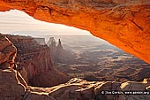 |
| Mesa Arch at Sunrise CANYONLANDS-NATIONAL-PARK-UTAH-USA-0001 |
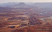 |
| The White Rim and Green River at Sunset CANYONLANDS-NATIONAL-PARK-UTAH-USA-0002 |
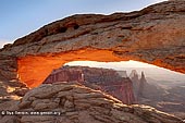 |
| Sunrise at Mesa Arch CANYONLANDS-NATIONAL-PARK-UTAH-USA-0003 |
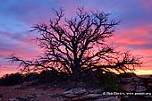 |
| Picturesque Tree Silhouette CANYONLANDS-NATIONAL-PARK-UTAH-USA-0004 |
 |
| Shafer Canyon Overlook CANYONLANDS-NATIONAL-PARK-UTAH-USA-0005 |
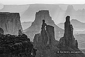 |
| Washer Woman Arch, Monster Tower and Airport Tower CANYONLANDS-NATIONAL-PARK-UTAH-USA-0006 |
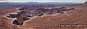 |
| Monument Basin at Sunrise CANYONLANDS-NATIONAL-PARK-UTAH-USA-0007 |
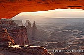 |
| Mesa Arch at Sunrise CANYONLANDS-NATIONAL-PARK-UTAH-USA-0008 |
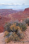
Canyonlands National Park is a U.S. National Park located in southeastern Utah near the town of Moab and preserves a colorful landscape eroded into countless canyons, mesas and buttes by the Colorado River, the Green River, and their respective tributaries. The park is divided into four districts: the Island in the Sky, the Needles, the Maze, and the rivers themselves. While these areas share a primitive desert atmosphere, each retains its own character. Two large river canyons are carved into the Colorado Plateau by the Colorado River and Green River. Canyonlands is the largest national park in Utah, and its diversity staggers the imagination. Author Edward Abbey, a frequent visitor, described the Canyonlands as "the most weird, wonderful, magical place on earth�there is nothing else like it anywhere." Island in the Sky is a sheer-walled mesa that constitutes the northern part of Canyonlands National Park. A scenic drive follows the rim of the mesa, with pullouts at vistas where you get amazing views out over the surrounding country, including rugged canyons that have been carved by the Colorado and Green rivers. In many places the surrounding country is 1,000 feet down, virtually straight down, from the top of the mesa. Island in the Sky is the most accessible district in Canyonlands. It is also close to Moab (only 32 miles / 51.5 km), and to Arches National Park. If time is limited, this area is the best choice for auto touring and short hikes. The scenic drive provides access to some of the park's most popular viewpoints, including: Grand View Point, Mesa Arch, Green River Overlook, Upheaval Dome. Nearby, Dead Horse Point State Park also offers incredible overlooks. The flat land at the top of the Island in the Sky mesa becomes narrower towards the south as the river confluence approaches. After the visitor center and entrance station, the first viewpoint is over Shafer Canyon to the east, a steep drainage containing a rough 4WD track that descends to the Colorado, becomes paved at the mining settlement of Potash and joins US 191 just north of Moab. To the west, the land drops away at the head of another canyon (Taylor), leaving quite a narrow strip of land in between (The Neck), but the plateau widens for the next few miles as the road crosses a flat meadow known as Grays Pasture, the original name for this whole area. The next canyon on the east (Trail) causes the plateau to split into two forks, as does the scenic drive. The west road leads past the main campground and an overlook of the Green River, both at Willow Flat, then descends gradually to the end of the mesa at Upheaval Dome. Also near the road junction are two short trails - to Mesa Arch, a graceful span of Navajo sandstone framing distant canyons to the northeast, and to some Anasazi granaries on Aztec Butte - plus one longer route (Wilhite) that descends to the White Rim and the Green River. Grand View Point. The remaining 5 miles of the main road cross a rather narrower plateau, past several overlooks, including Buck Canyon, Candlestick Tower, Murphy Point (at the end of a 1.7 mile trail), Gooseberry Canyon and the Orange Cliffs. The park road ends at Grand View Point, which offers magnificent vistas across the Colorado canyons and the spires of Monument Basin, to the distant La Sal mountains in the east and the Needles area to the south. A further one mile, 20 minute walk southwards along the Grand View Trail leads to the very end point of the Island in the Sky plateau, where the cliffs drop away in all directions, and the canyons of both rivers can be seen. The actual confluence point is hidden, but can be reached by a long trail starting in the Needles section of the park. The White Rim is a wide flat plateau halfway in height between the Island in the Sky and the Green/Colorado rivers, formed by a layer of white sandstone much more resistant to erosion than the strata above or below. A 100 mile track built by uranium prospectors after World War 2 winds along the edge of the rim; driving the full distance is said to take 2 days and a few parts require 4WD even though much is level and quite easy to navigate. A reservations system operates to regulate the limited number of primitive camp sites en route. This was the road featured at the end of the film Thelma and Louise, when the heroines drove over the edge, apparently thinking that they had found the Grand Canyon. Access is by the Mineral Bottom Road in the west and the Shafer Trail in the east. The best viewpoint of the rim, and of Monument Basin, is by the short White Rim Overlook Trail. The Needles District forms the southeastern portion of Canyonlands National Park. Its signature features are colorful sandstone spires - hundreds of them poking up from the desert floor. There are also entrenched canyons, natural arches and sheer-walled cliffs in this vast, rugged landscape. This area is famous for its rough jeep trails, including some that rank with the most challenging in the world. You need a high clearance 4X4 vehicle optimized for off-road travel to drive some of the routes here. The Maze is the least accessible district of Canyonlands. It's big, wild, remote and untamed. Roads require high-clearance four-wheel-drive. There are no amenities - no food, no water, no gasoline. There is no entrance fee here but permits are required for overnight trips. Because of the remoteness and the difficulty of roads and trails, travel to the Maze requires more time, as well as a greater degree of self-sufficiency. Rarely do visitors spend less than three days in the Maze, and the area can easily absorb a week-long trip. Horseshoe Canyon is a remote extension of Canyonlands National Park. It contains some of the most significant rock art in North America, including "The Great Gallery," which offers well-preserved, life-sized humanoid figures with intricate designs. Horseshoe Canyon offers excellent hiking opportunities. Canyonlands is a paradise for photographers. Under conditions of constantly changing light, the varicolored landscape provides limitless photographic opportunities. Often, the difference between an average photograph and an exceptional photograph is good lighting. Low sun angles at sunrise and sunset can add brilliant color to the rock. Scattered clouds can also add depth to an image and a passing storm can provide extremely dramatic lighting.
|