Photography, Australian Landscape Photography, Panoramic Photos, |
|
Photography, Australian Landscape Photography, Panoramic Photos, |
|
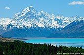
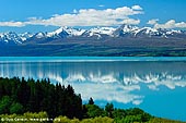
Lake Pukaki is the lake in central South Island, New Zealand, east of the Aoraki/Mount Cook National Park. Lake Pukaki is the largest of three roughly parallel alpine lakes running north-south along the northern edge of the Mackenzie Basin on New Zealand's South Island. The others are Lakes Tekapo and Ohau. All three lakes were created when the terminal moraines of receding glaciers blocked their respective valleys, forming moraine-dammed lakes. The Tasman River, which flows from the nearby Tasman and Hooker Glaciers, close to Aoraki/Mount Cook, feeds Lake Pukaki. The glacial feed to the lakes gives them a distinctive blue colour, created by glacial flour, the extremely finely ground rock particles from the glaciers. Lake Pukaki offers beautiful scenery of unusually blue lake and peaks of the Southern Alps. On a clear non-windy day the mountain peak Aoraki/Mount Cook (3764 m) - the highest mountain in New Zealand reflects in Lake Pukaki. At the southern bank of the lake along the national road there is a beautiful view of the whole Lake Pukaki and the surrounding Southern Alps. Lake Pukaki is a great spot for landscape photographers and due to its North-South orientation you can shoot Aoraki/Mount Cook at sunrises and at sunsets. There are numerous interesting photography options exist along the shoreline even if the mountain is obscured by clouds. These include seasonal ponds, mini-islands and fascinating rock formations. Several major tourist attractions can be found nearby. These include Aoraki/Mount Cook National Park about 55 km to the North, Westland National Park about 62 km to the North-West, Lake Tekapo about 27 km to the East and Lake Ohau about 33 km to the West.
|