Photography, Australian Landscape Photography, Panoramic Photos, |
|
Photography, Australian Landscape Photography, Panoramic Photos, |
|
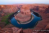
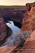
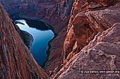
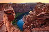
Northern Arizona and southern Utah are abundant in scenic landscapes. Strong winds carrying fine desert sand and the mighty Colorado river erode the rocks in the region to create exquisite shapes and patterns. The region is popularly known as the Grand Circle and encompasses more than a dozen State and National Parks including Grand Canyon, Bryce Canyon, Antelope Canyon, Arches National Park and Canyonlands National Park. Among them is a peculiar geological formation � the Horseshoe Bend. Horseshoe Bend is the name for a horseshoe-shaped meander of the Colorado River located near the town of Page, Arizona, in the United States. The bend is locally known as "King Bend". It is located five miles (8.7 km) downstream from the Glen Canyon Dam and Lake Powell within Glen Canyon National Recreation Area, about four miles or 6 km southwest of Page. Accessible via half a mile (0.8 km) hike from U.S. Route 89, Horseshoe Bend can be viewed from the steep cliff above. The overlook is 4,200 feet above sea level and the Colorado River is at 3,200 feet above sea level making it a breathtaking 1,000 foot drop. As most of Glen Canyon is submerged beneath Lake Powell, the only intact section is downstream of the dam, where the Colorado River flows through the 1,000 foot deep ravine for 15 miles, until the cliffs open out at Lees Ferry. Apart from viewpoints around the US 89 bridge and the dam itself, the canyon can be seen via two trails - the lightly used and rather strenuous Spencer Trail starting at Lees Ferry or the much easier and very popular half mile path to Horseshoe Bend Overlook, where the river curves round by 270 degrees. This is one of the most spectacular and often-photographed places in Arizona. The Horseshoe Bend Overlook is served by a large parking area on the west side of US 89, 5 miles south of Glen Canyon Dam; big enough to accommodate the tour buses that often stop here. The adjacent land, and the viewpoint, are actually just south of the Glen Canyon National Recreation Area boundary, on the Navajo Reservation, but the trail is managed by the NPS. The wide path climbs a little to a low, flat-topped hill then descends gently down the far side, across a mix of slickrock and dunes to the unfenced overlook, on the rim of cliffs that are quite sheer for most of the 1,100 foot drop to the river below. The water in the Colorado is slow moving, greenish blue in color and edged by thin strips of bright green vegetation - a striking contrast to the red-brown Navajo sandstone cliffs at either side. There are often several rafts and boats in view, making the short upstream journey from Lees Ferry; sandbanks and bushy areas along the river provide many stopping places. People looking for a "beautiful death" often choose Horseshoe Bend as a place to jump into their "next life". So the Horseshoe Bend Overlook is rightfully considered the suicide capital of Arizona. |