Cameron Corner and Corner Country Photos
Cameron Corner, Tibooburra, Wild Dog (Dingo) Fence , New South Wales (NSW), Australia

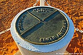


Cameron Corner is iconic and the most remote location in New South Wales outback, and one of the busiest. Each year several thousand people pass this way, either heading toward the Strzelecki Track, or into the Corner Country from South Australia. Some even cross over from Queensland. Cameron Corner lies at the intersection of the New South Wales-Queensland border (the 29th parallel) and New South Wales-South Australia border (141st meridian) in about 140kms from Tibooburra. This general area, which includes Strzelecki Desert in the Lake Eyre Basin was first explored by Captain Charles Sturt, during Sturt's Central Australian Expedition, who in 1844 went in search of a supposed inland sea in the center of Australia. The place was named after the New South Wales Lands Department Surveyor, John Brewer Cameron who surveyed this area in 1880. Cameron Corner Store was first opened there by Sandy Nall in May 1989. Now Cheryl and Fenn Miller own Cameron Corner Store. The Cameron Corner Store and a golf course near there "is a Queensland business with a New South Wales postal code and a South Australian telephone number." The Cameron Corner Store is open seven days for meals, fuel, minor vehicle repairs, souvenirs and cabin accommodation or powered camp sites.
Dingo fence (also known as Wild Dog Fence) is one of the longest structures in the world and is the world's longest fence. It stretches 5,614 km (3,488 mi) from Jimbour on the Darling Downs near Dalby through thousands of kilometres of arid land ending west of Eyre peninsula on cliffs of the Nullarbor Plain above the Great Australian Bight, near Nundroo. Originally built in the 1890s to help control the enormous rabbit population which was devastating huge areas of inland and regional Australia, the fence was converted to a dingo fence in 1914 to prevent dingoes entering sheep grazing areas. There are several locations where the fence is visible to travellers: Cameron Corner, west of Tiboburra, Warri Gate to the north of Tibooburra, and at various locations south of the Hawker Gate Road. Driving adjacent to most sections of the fence is not possible.
Tibooburra is a village in the far northwest of New South Wales, Australia, 1,187 kilometres (738 mi) from the state capital, Sydney. Pronounced "Tibberburra" or "Tipperburra" by locals, it is most frequently visited by tourists on their way to national parks in the area. The town's name could be derived from an aboriginal word for heap of boulders and the main natural tourist attraction is the remarkable granite rock outcrops which erupt immediately beside (and even among) the town streets. Tibooburra was established at the height of the gold rush, and many historic buildings, harking back to the pioneering era, are found about the town. Nearby is Sturt National Park, which incorporates Cameron Corner, where the borders of three States meet: Queensland, South Australia and New South Wales. Tibooburra is the hottest town in New South Wales and is the capital of the Corner Country.
About the Artist
I'm Ilya Genkin - an internationally recognised Australian landscape and fine art photographer offering wall art prints. My passion for capturing the beauty of nature and our world translates into striking photographic prints that bring life, emotion, and inspiration to any space. From tranquil seascapes to dramatic mountainscapes, each image is a reflection of my vision and dedication to the art of photography.
Read more about Ilya Genkin and shop fine art prints online from his collection.
Wall Art Prints Featuring Fine Art Landscape Photography
Explore my extensive collection of wall art prints - crafted with the highest-quality materials to suit every style and budget. Whether you're looking for a luxurious, ready-to-hang piece or a beautifully printed work to frame yourself, each photograph is available in several premium formats: Gallery-quality Fine Art Paper Prints - ready for framing, and Professional Canvas Prints - classic and timeless texture.
Each artwork is meticulously printed and made-to-order to ensure you receive a piece that elevates your home, office, or commercial space. Buy fine art prints online to suit your style.
Artworks for Interior Designers, Home Stylists, and Architects
I collaborate with interior designers, home stylists, and architects to create bespoke wall art prints tailored to your project's aesthetic, colour palette and interior design needs. Prints can be customised and sized to complement your space perfectly. All pieces are made-to-order, and pricing varies based on size, quantity, and shipping.
Contact me to discuss your project and request a personalised quote.
Why Choose Ilya Genkin Photography?
By choosing my work, you're not just acquiring exceptional art - you're supporting an independent Australian artist and contributing to a vibrant local creative community. Every purchase directly helps sustain and grow this craft, bringing authentic and meaningful art into your life.
Request a free mockup to see how a chosen photograph will look in your space before you buy.
Start your journey today - shop our wall art collection, purchase with confidence, or order custom prints today and transform your walls with fine art photography.
Fine Art Landscape Photography
Information
- FAQ - Landscape Photography Prints
- Purchase Fine Art Prints
- Black and White Fine Art Prints
- Art Consultation for Your Home
- Design Tips for Styling Your Space with Art
- Limited Edition vs Open Edition Prints
- Collector Resources
- FAQ - Image Licensing
- License Stock Photos
- Stock Photo Price Request
- Materials and Sustainability
Photography Guides
Online Store Opens 24/7
Email:
Phone: +61 (0) 421 055 613

Crafted with care for the planet - using sustainable materials and eco-friendly packaging.
Ilya Genkin Photography acknowledges the Traditional Custodians of the land on which we operate, live and gather as employees, and recognise their continuing connection to land, water and community. We pay respect to Elders past, present and emerging.