Cobar Photos
New South Wales (NSW), Australia


Cobar is a town in central western New South Wales, Australia. It is located 712 km (442 miles) northwest of Sydney. It is at the crossroads of the Kidman Way (to Queensland) and Barrier Highway (to South Australia). The town and the Local Government Area, the Cobar Shire, are on the eastern edge of the Australian outback. The name Cobar is derived from the Aboriginal Ngiyampaa word Kuparr, Gubarr or Cuburra, meaning 'red earth' or 'burnt earth', the ochre used in making body paint for Corroborees. It has also been suggested, but it is less likely, that the name may represent an Aboriginal attempt to pronounce the word 'copper'.
Cobar has a lot of tourist attractions that reflect the town's mining and rural background. From the Great Cobar Copper Mine to the rugged beauty of our outback landscape, Cobar has plenty to offer to history and nature lovers.
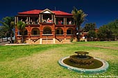
One must-see is the Great Cobar Heritage Centre with its collection of interesting exhibits focusing on the town's mining, agricultural and Aboriginal history. The Centre is the starting point for the Cobar Heritage Walk, which takes in many grand old buildings and other points of interest such as the Cobar Miners' Heritage Park. The Great Cobar Heritage Centre was originally built in 1910 as the administration building for the Great Cobar Copper Mine.
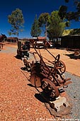
Just across the road from the Heritage Centre is the Cobar Mining Heritage Park. It was created to commemorate the miners who lost their lives throughout Cobar's mining history.
The Great Cobar Copper Mine, which was founded in 1870, was one of the world's largest mining and processing operations in its day. Its main mine shafts run to 430 metres and are now fenced off, south of the Heritage Centre. The remains of the smelter foundations are visible from the top of the hill, east of the Heritage Centre.
The Great Cobar Open Cut was originally a 150 metre deep open-cut mine, but is now a popular local swimming hole. The Great Cobar Open Cut was created more than a century ago using picks and shovels and horse and cart. Men removed rock from this quarry to be used as backfill for the underground mine stopes using the cut and fill method.
Just a few kilometres east of Cobar, visitors can get a panoramic view of the town and the New Cobar Open Cut Gold Mine at Fort Bourke Hill. A viewing on platform overlooks the open pit of the Peake Gold Mine and the entrance to the underground mine. Fort Bourke Hill is 300 metres above sea level and Cobar's mineral belt becomes obvious as you line up the head-frames running north to south.
About the Artist
I'm Ilya Genkin - an internationally recognised Australian landscape and fine art photographer offering wall art prints. My passion for capturing the beauty of nature and our world translates into striking photographic prints that bring life, emotion, and inspiration to any space. From tranquil seascapes to dramatic mountainscapes, each image is a reflection of my vision and dedication to the art of photography.
Read more about Ilya Genkin and shop fine art prints online from his collection.
Wall Art Prints Featuring Fine Art Landscape Photography
Explore my extensive collection of wall art prints - crafted with the highest-quality materials to suit every style and budget. Whether you're looking for a luxurious, ready-to-hang piece or a beautifully printed work to frame yourself, each photograph is available in several premium formats: Gallery-quality Fine Art Paper Prints - ready for framing, and Professional Canvas Prints - classic and timeless texture.
Each artwork is meticulously printed and made-to-order to ensure you receive a piece that elevates your home, office, or commercial space. Buy fine art prints online to suit your style.
Artworks for Interior Designers, Home Stylists, and Architects
I collaborate with interior designers, home stylists, and architects to create bespoke wall art prints tailored to your project's aesthetic, colour palette and interior design needs. Prints can be customised and sized to complement your space perfectly. All pieces are made-to-order, and pricing varies based on size, quantity, and shipping.
Contact me to discuss your project and request a personalised quote.
Why Choose Ilya Genkin Photography?
By choosing my work, you're not just acquiring exceptional art - you're supporting an independent Australian artist and contributing to a vibrant local creative community. Every purchase directly helps sustain and grow this craft, bringing authentic and meaningful art into your life.
Request a free mockup to see how a chosen photograph will look in your space before you buy.
Start your journey today - shop our wall art collection, purchase with confidence, or order custom prints today and transform your walls with fine art photography.
Fine Art Landscape Photography
Information
- FAQ - Landscape Photography Prints
- Purchase Fine Art Prints
- Black and White Fine Art Prints
- Art Consultation for Your Home
- Design Tips for Styling Your Space with Art
- Limited Edition vs Open Edition Prints
- Collector Resources
- FAQ - Image Licensing
- License Stock Photos
- Stock Photo Price Request
- Materials and Sustainability
Photography Guides
Online Store Opens 24/7
Email:
Phone: +61 (0) 421 055 613

Crafted with care for the planet - using sustainable materials and eco-friendly packaging.
Ilya Genkin Photography acknowledges the Traditional Custodians of the land on which we operate, live and gather as employees, and recognise their continuing connection to land, water and community. We pay respect to Elders past, present and emerging.