Mount Gambier
South Australia (SA), Australia


Mount Gambier is the largest regional city in South Australia located approximately 450 kilometres south of the capital Adelaide and just 17 kilometres from the Victorian border. It takes its name from the Mount Gambier, a crater sighted in 1800 by Lieutenant James Grant from the survey brig, HMS Lady Nelson, and named for Lord James Gambier, Admiral of the Fleet.
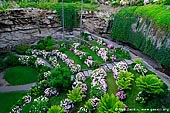
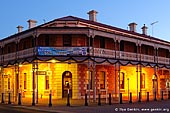
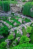
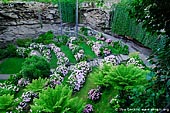
Mount Gambier, a prominent city in the Kanawinka Geopark, is known as the city of craters, lakes, caves and sinkholes. It is known as Australia's most extensive volcanic provincial city. The city sits about 75 meters above sea level and is the regional centre of the Limestone Coast. Visitors will be impressed by the beautifully restored historic buildings. The caves were formed by dissolving limestone. The limestone at the Engelbrecht Cave, below the city's streets, is about 100 metres thick. Thought to be 30 to 40 million years old, it is very popular with cave divers. The Umpherston Sinkhole is probably the most popular attraction and was created when the cave imploded. The floor of the cave now forms the Sunken garden. Another sinkhole, the amazing Cave Gardens in the centre of town, is famous for its roses.
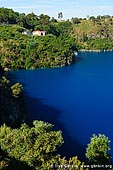
One of Mount Gambier's major tourist attractions is undoubtedly the majestic Blue Lake. It is a unique attraction, situated in an extinct volcanic crater. With its water colour changing from a sombre blue in winter to a brilliant turquoise in summer, Blue Lake is one of the region's most visited attractions. The cause of the transformation of colours has been identified as calcite precipitation. The lake has a 3.5 kilometre circumference and can be enjoyed all year round. You can also take guided tours of the lake.
About the Artist
I'm Ilya Genkin - an internationally recognised Australian landscape and fine art photographer offering wall art prints. My passion for capturing the beauty of nature and our world translates into striking photographic prints that bring life, emotion, and inspiration to any space. From tranquil seascapes to dramatic mountainscapes, each image is a reflection of my vision and dedication to the art of photography.
Read more about Ilya Genkin and shop fine art prints online from his collection.
Wall Art Prints Featuring Fine Art Landscape Photography
Explore my extensive collection of wall art prints - crafted with the highest-quality materials to suit every style and budget. Whether you're looking for a luxurious, ready-to-hang piece or a beautifully printed work to frame yourself, each photograph is available in several premium formats: Gallery-quality Fine Art Paper Prints - ready for framing, and Professional Canvas Prints - classic and timeless texture.
Each artwork is meticulously printed and made-to-order to ensure you receive a piece that elevates your home, office, or commercial space. Buy fine art prints online to suit your style.
Artworks for Interior Designers, Home Stylists, and Architects
I collaborate with interior designers, home stylists, and architects to create bespoke wall art prints tailored to your project's aesthetic, colour palette and interior design needs. Prints can be customised and sized to complement your space perfectly. All pieces are made-to-order, and pricing varies based on size, quantity, and shipping.
Contact me to discuss your project and request a personalised quote.
Why Choose Ilya Genkin Photography?
By choosing my work, you're not just acquiring exceptional art - you're supporting an independent Australian artist and contributing to a vibrant local creative community. Every purchase directly helps sustain and grow this craft, bringing authentic and meaningful art into your life.
Request a free mockup to see how a chosen photograph will look in your space before you buy.
Start your journey today - shop our wall art collection, purchase with confidence, or order custom prints today and transform your walls with fine art photography.
Fine Art Landscape Photography
Information
- FAQ - Landscape Photography Prints
- Purchase Fine Art Prints
- Black and White Fine Art Prints
- Art Consultation for Your Home
- Design Tips for Styling Your Space with Art
- Limited Edition vs Open Edition Prints
- Collector Resources
- FAQ - Image Licensing
- License Stock Photos
- Stock Photo Price Request
- Materials and Sustainability
Photography Guides
Online Store Opens 24/7
Email:
Phone: +61 (0) 421 055 613

Crafted with care for the planet - using sustainable materials and eco-friendly packaging.
Ilya Genkin Photography acknowledges the Traditional Custodians of the land on which we operate, live and gather as employees, and recognise their continuing connection to land, water and community. We pay respect to Elders past, present and emerging.