Port Stephens
Anna Bay, Boat Harbour, Fingal Bay, Nelson Bay, One Mile, Fisherman's Bay, Shoal Bay and Soldiers Point, New South Wales (NSW), Australia


Port Stephens is a large natural harbour located about 160 kilometres (99 mi) north-east of Sydney in New South Wales, Australia. Port Stephens is a popular tourism destination with a strong focus on aquatic activities such as whale and dolphin watching, fishing and recreational boating.
Nelson Bay is a suburb of the Port Stephens Local Government Area in the Hunter Region of New South Wales, Australia. It is located on a bay of the same name on the southern shore of Port Stephens. It is a major tourism centre, particularly for dolphin and whale watching, surfing, diving, fishing and other recreational aquatic activities. The eastern boundaries of Nelson Bay lie within the Tomaree National Park while the southeastern section is almost entirely within the park. Nelson Head Light, an unusual lighthouse built in 1875, is positioned on the northeast corner.
Shoal Bay is the most eastern suburb of the Port Stephens. It is located on the southern shore of Port Stephens, adjacent to the bay of the same name at the entrance to the port. It includes part of Tomaree National Park within its boundaries and, like other suburbs around Port Stephens, is a popular tourist destination, especially in summer months.
One Mile is a suburb of the Port Stephens and it is semi-rural with a small urban settlement west of Gan Gan Road and a number of caravan parks to the east of Gan Gan Road. The parks are positioned to provide quick access to the suburb's two beaches. One Mile Beach, after which the area was named, is a family-friendly surf beach that is popular with tourists while Samurai Beach is clothing optional. Both beaches, like a large percentage of the locality, lie within the Tomaree National Park. The beaches form most of the coastline in Anna Bay which gave the adjacent suburb of Anna Bay its name. Although the suburb is formally called One Mile residents often refer to it as One Mile Beach. Even some road signs identify the area incorrectly as One Mile Beach.
Anna Bay is the name of a suburb, a town and a bay in the Port Stephens. It is adjacent to the north-eastern end of Stockton Beach and the town provides one of the major entry points to the beach here. Anna Bay was named after the bay of the same name which is now located in the adjacent suburb of One Mile. During World War II Stockton Beach was heavily fortified against a possible amphibious assault by Imperial Japanese forces and a line of tank traps was installed to prevent entry to the local area through the town. Many of the tank traps were removed after the war and now feature significantly around the car parking areas at the beach.
Fishermans Bay is a small suburb of the Port Stephens and it is located on the coast of the Tasman Sea adjacent to Anna Bay. A large part of the eastern portion of the suburb is occupied by Tomaree National Park and only a very small portion of the south western corner of the suburb is populated. The suburb is named after the adjacent bay.
Boat Harbour is a suburb of the Port Stephens. It lies adjacent to the bay after which it was named. From the eastern most end of Ocean Parade in highest part of the suburb, adjacent to the Tomaree National Park at Morna Point, there are striking views of the coastline. On a clear day it is possible to follow the coast southwards to the horizon, well beyond Newcastle. Boat Harbour is a sheltered, sandy bay. Kingsley Beach is just to the south and is popular with surfers.
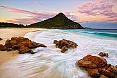
Fingal Bay is the eastern-most suburb of the Port Stephens Local Government Area. The only population centre is the township of the same name, which itself is named after the adjacent, small, semi-circular bay. Except for the township, most of Fingal Bay is included in the Tomaree National Park, which includes forested areas, coastal scrubland, beaches and most of the Fingal headland. The suburb does not include the bay itself. The bay was originally known as 'False Bay', because it could be mistaken for the entrance to Port Stephens. The name 'Fingal Bay' appeared on an 1845 map prepared by Captain Phillip Parker King.
Fingal Bay is approximately 1.75 km (1.1 mi) across at its widest point and 1.3 km (0.8 mi) from the mouth to the beach. The northeastern head of the bay is the Fingal headland, which is connected to the mainland via Fingal Spit, a sand spit approximately 900 m (2,953 ft) long. Waters to the northeast of the spit are known as 'Fly Roads'. Crossing between the mainland and the headland along the spit is considered dangerous. According to a sign on the beach, people have died crossing the spit, which can be covered by breaking waves at times. The south-western head of the bay is Fingal Head, which is located southeast of the town. Between the two heads, the mouth is over 1 km (0.6 mi) wide. The bay includes a sandy beach approximately 1.9 km (1.2 mi) long.
About the Artist
I'm Ilya Genkin - an internationally recognised Australian landscape and fine art photographer offering wall art prints. My passion for capturing the beauty of nature and our world translates into striking photographic prints that bring life, emotion, and inspiration to any space. From tranquil seascapes to dramatic mountainscapes, each image is a reflection of my vision and dedication to the art of photography.
Read more about Ilya Genkin and shop fine art prints online from his collection.
Wall Art Prints Featuring Fine Art Landscape Photography
Explore my extensive collection of wall art prints - crafted with the highest-quality materials to suit every style and budget. Whether you're looking for a luxurious, ready-to-hang piece or a beautifully printed work to frame yourself, each photograph is available in several premium formats: Gallery-quality Fine Art Paper Prints - ready for framing, and Professional Canvas Prints - classic and timeless texture.
Each artwork is meticulously printed and made-to-order to ensure you receive a piece that elevates your home, office, or commercial space. Buy fine art prints online to suit your style.
Artworks for Interior Designers, Home Stylists, and Architects
I collaborate with interior designers, home stylists, and architects to create bespoke wall art prints tailored to your project's aesthetic, colour palette and interior design needs. Prints can be customised and sized to complement your space perfectly. All pieces are made-to-order, and pricing varies based on size, quantity, and shipping.
Contact me to discuss your project and request a personalised quote.
Why Choose Ilya Genkin Photography?
By choosing my work, you're not just acquiring exceptional art - you're supporting an independent Australian artist and contributing to a vibrant local creative community. Every purchase directly helps sustain and grow this craft, bringing authentic and meaningful art into your life.
Request a free mockup to see how a chosen photograph will look in your space before you buy.
Start your journey today - shop our wall art collection, purchase with confidence, or order custom prints today and transform your walls with fine art photography.
Fine Art Landscape Photography
Information
- FAQ - Landscape Photography Prints
- Purchase Fine Art Prints
- Black and White Fine Art Prints
- Art Consultation for Your Home
- Design Tips for Styling Your Space with Art
- Limited Edition vs Open Edition Prints
- Collector Resources
- FAQ - Image Licensing
- License Stock Photos
- Stock Photo Price Request
- Materials and Sustainability
Photography Guides
Online Store Opens 24/7
Email:
Phone: +61 (0) 421 055 613

Crafted with care for the planet - using sustainable materials and eco-friendly packaging.
Ilya Genkin Photography acknowledges the Traditional Custodians of the land on which we operate, live and gather as employees, and recognise their continuing connection to land, water and community. We pay respect to Elders past, present and emerging.