Northern Beaches
Sydney, New South Wales (NSW), Australia
Discover the beauty of Sydney's coastline through my Sydney Northern Beaches Wall Art Prints and Sydney Eastern Beaches Wall Art Prints collections. From Palm Beach and Narrabeen to Bondi and Coogee, these fine art photographs capture golden sunrises, sweeping surf, and dramatic headlands, making them perfect for transforming your walls into windows onto the ocean.
Related subjects: Sydney Eastern Beaches.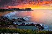


Discover the beauty of Sydney's coastline through my Sydney Northern Beaches Wall Art Prints and Sydney Eastern Beaches Wall Art Prints collections. From Palm Beach and Narrabeen to Bondi and Coogee, these fine art photographs capture golden sunrises, sweeping surf, and dramatic headlands, making them perfect for transforming your walls into windows onto the ocean.
Related subjects: Sydney Eastern Beaches.The Northern Beaches is an area in the northern coastal suburbs of Sydney, in the state of New South Wales, Australia, located near the coast of the Pacific Ocean. This area extends south to the entrance of Port Jackson (Sydney Harbour), west to Middle Harbour and north to the entrance of Broken Bay.
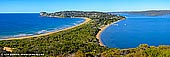
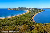
Palm Beach, the jewel of the Northern Beaches, is the northernmost of Sydney's Northern Beaches and the most northerly suburb of the city's metropolitan area. It is located in about 28 kilometres north from Manly and about 40 kilometres (a good 45 mins - 1 hour drive) from the Sydney Opera House, Sydney Harbour Bridge and Sydney CBD. Palm Beach is home to many of Sydney's rich and famous and the ideal place to buy a weekender if you have a few million to spare. Palm Beach is one of the largest of Sydney's beaches, being approximately 2-3 km long along the Pacific Ocean shore. The beachside suburb of Palm Beach backs on to Pittwater, a large southern inlet of Broken Bay, making the locality about as surrounded by water as is possible, without actually being an island.
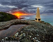
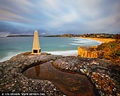
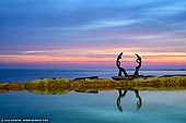
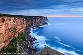
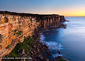
Barrenjoey is a locality in the suburb of Palm Beach, at the farthest southern tip of Pittwater. Around 10,000 years ago the headland was cutoff from the mainland due to the rising sea level; subsequent buildup of a sand spit or tombolo (a deposition landform in which an island is attached to the mainland by a narrow piece of land such as a mound, spit or bar) reconnected the island to the mainland. It is the location of Barrenjoey Head Lighthouse, a lighthouse which was first lit in 1881. On 2 March 1788, Governor Arthur Phillip named the headland 'Barrenjuee' or 'Barrenjoey' (meaning little kangaroo or wallaby, hence 'joey'). The area's name has been spelled differently over time, Barrenjoey now being the accepted name since 1966. The stretch of water was named Pittwater after William Pitt who was Prime Minister in England from 1783-1801.
The southern end of the Palm Beach is marked as Cabbage Tree Boat Harbour on a map of 1832. Palm Beach was later named after the Cabbage Tree palms livistona australis that were near Cabbage Tree Boat Harbour. The plant's species name gave origin to Livistona Lane, off Palm Beach Road. However if you look at the Palm Beach and Barrenjoey Headland from above or on a map it will look like a palm tree as well. So many people believe that the Palm Beach was named because of the shape of the Barrenjoey Headland and the very long spit.
Palm Beach is used for exterior filming of popular Australian soap opera Home and Away, as the fictional town of Summer Bay. Fans of the show will easily recognise some of the local views. Its iconic status amongst the Sydney beach culture is reflected in artworks, poetry and prose. Palm Beach has a limited selection of accommodation, excellent world-class restaurants and a good selection of cafes. Pittwater is very popular with yachtsman, while golfers enjoy the Palm Beach golf course. Palm Beaches long stretch of golden beach is excellent for beach-goers and for uncrowded surfing when compared to other popular beaches closer to Sydney.
At the end of the spit near the beginning of the Barrenjoey Head a not-too-difficult uphill walk ends at the historic Barrenjoey lighthouse with spectacular 360 degree views including Lion Island, an uninhabited rocky island resembling a resting lion which guards the entrance to Broken Bay, its northern arm Brisbane Water, and Pittwater. The trip to the Barrenjoey lighthouse takes 20 minutes or 35 minutes according to the steepness of the two alternatives. The Barrenjoey Head lighthouse was the third light constructed on the headland, and was built of the rich-coloured local sandstone in 1881. At an elevation of 113 m, it is visible to a distance of 19 nautical miles (35 km; 22 mi) out to sea. Tours run every Sunday (weather permitting). Cost is $3 for adults and $2 for children and no bookings required.
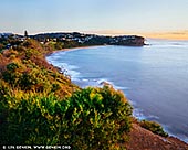
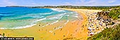
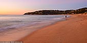
Whale Beach is a northern beachside suburb of Sydney, in the state of New South Wales, Australia. Whale Beach is located 40 kilometres north of the Sydney central business district, in the local government area of Pittwater Council, in the Northern Beaches region. It is a favourite tourist destination alongside neighboring Palm Beach and it is a choice spot for grand vacation homes of the rich and famous. It has complete beach amenities such as picnic and barbecue areas, as well as lifeguards during holidays and weekends. With several great resorts around its perimeter, lovely restaurants and a panoramic view of the Pacific Ocean, Whale Beach is the perfect place for that family summer trip or a tryst with your friends. The water is wonderful for swimming and other water activities, and you can knock yourself out playing games on the shore. Whale Beach is also known for a popular surfing break called "The Wedge".
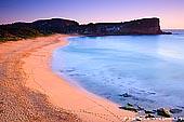
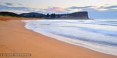
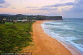
Avalon Beach is a famous surfing beach and it is located in the Northern Beaches area of Sydney, Australia. Avalon Beach is located 35 kilometres north of the Sydney central business district, in the local government area of Pittwater Council. Avalon Beach is extremely picturesque and full of natural beauty as it lays nestled between the two imposing headlands.
Avalon was named after the mythical Avalon, a legendary island in Celtic languages mythology. According to legends, Avalon was an earthly paradise and the final resting place of King Arthur.
Avalon is home to the few remaining koalas able to survive in an increasingly urban environment, a reminder that there once were many more in Pittwater.
Avalon Beach is superb for swimming, surfing windsurfing and fishing. At the southern end of the beach is a large salt water pool which provides a protected environment for adults and children alike who prefer to swim in calmer waters. A shady park area provides refuge from the summer sun, together with picnic and barbeque facilities. Avalon Beach is a great place to take a day trip to if you're visiting Sydney or live south or west of the city.
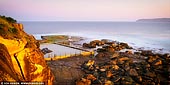
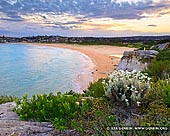
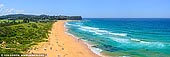
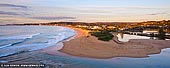
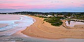
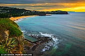
Mona Vale is a suburb of Sydney located in the Northern Beaches area. To the north is Newport, to the south Warriewood, to the west Bayview, and to the east the Pacific Ocean. Mona Vale Beach is a long shallow beach at the junction of Mona Vale, Pittwater and Barrenjoey Roads in Sydney's Northern Beaches region. There are actually two beaches - the Basin and Mona Vale Beach, separated by a broad ocean rock platform. Waves that roll in along the southern edge of the platform surge into a gully that allows them to break smoothly and with considerable power. Mona Vale Beach is a popular family beach with playground and barbecue facilities but there are sections with dangerous rips. Beach inspectors patrol the beach during daylight hours from the September school holidays until the Anzac Day weekend. In summer, volunteer lifesavers are present on weekends and public holidays.
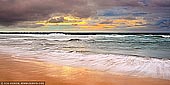
Sydney has a reputation for some of the most beautiful beaches in the world and most of Sydney's northern beaches make great locations for landscape and seascape photographs. The Mona Vale Beach is one them - "a picture paradise". It is relatively secluded, with a wealth of different photographic options. A wonderful combination of sandy beach, thundering surf and reflective rockpools - the place has it all!
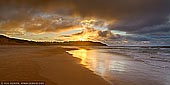
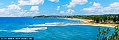
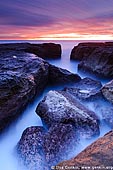
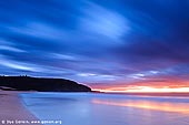
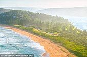
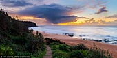
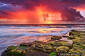
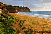
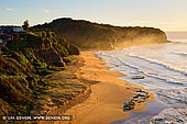
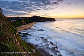
The Turimetta Beach is one of my favourite photography spots - nice, quiet and small 350m long beach between North Narrabeen and Mona Vale on famous Sydney's Northern Beaches and it is backed by steep bluffs.
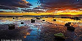
The Turimetta Beach is both a hidden jewel and also a very popular spot for seascape photographers. This location is an extremely popular spot with local landscape and seascape photographers due to beautiful green moss covered rocky inlet and its constantly evolving landscape with the shifting sands. You can find photographers there almost at every morning including weekdays. Some times you can see up to 10 - 15 people shooting pictures on the southern part of the beach which is the most photogenic, with lovely angular rocks stacked up against the ocean. During Australia's late Winter and early Spring (July-September) rocks on Turimetta Beach are covered in a bright green weed and moss which make the rocks look very attractive for photography.
You can shoot Turimetta Beach at any tide however the beach looks totally different depending on the tides. The medium tide is probably the best for photography as interesting rock formations are still showing and there is sufficient water flow to capture. At low tide it is possible to walk to North Narrabeen and the rock pool there. However at high tide all these rocks (and especially mossy ones) are extremely slippery, and, regardless of how low tide is, an occasional wave can wash you off the rock.
Access to the beach start at the Narrabeen Park Parade (northern part) and Peal Place (southern part). The stairs at the Peal Place lead you down onto the beach and bring you to the main rock shelf at the foot of the headland. There is also a short trail from the Peal Place through the Narrabeen Head Reserve that leads to the Turimetta Lookout and North Narrabeen Lookout.
From the Narrabeen Park Parade you can get to onto another rock shelf and if tide permits walk further round to Warriewood blowhole (sometimes called 'Canyon X'). There are some amazing caves and rock formations on the way there. Warriewood blowhole is also accessible from Narrabeen Park Parade by a short abseil down a fishermen's rope attached to the cliff face. One rope is about a 3m drop and then the next is about a 2m drop.
The Turimetta Beach receives waves averaging 1.5m which break close to shore, and often has a heavy shore break. Swimming can be hazardous because of rips that usually form at the centre amongst the rocks and both ends of the beach. The beach is not patrolled by lifeguards. Turimetta is popular with beachgoers wanting to escape the crowds. The beach offers a bit of a left over the northern rocks and reef, but more often short beach breaks. The northern Turimetta rock platform is the site of a treated sewerage outlet, however it is also the most popular fishing site. The beach has both gutters and exposed rocks following large seas, while the southern rocks are wide and flat and give access to a deeper sand and rock seafloor.
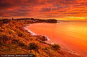
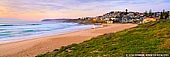
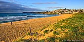
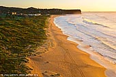
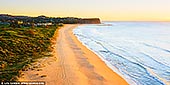
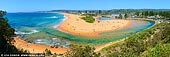
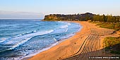
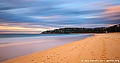
Narrabeen Beach is a suburb of Sydney located 23 kilometres north-east of the Sydney central business district, in the Northern Beaches area. North Narrabeen is renowned as one of the great surf breaks of the world. It is one of Australia's iconic surfing and swimming beaches. Over three kilometres of sand stretch from Long Reef in the south to the Narrabeen Lagoon entrance in the north.
Narrabeen-Collaroy beach is Sydney's second longest beach. The 3.6 km long beach curves in a gentle east-facing arc between 20 m high Narrabeen Head in the north to rocks and low cliff at Collaroy Point, with beachfront houses and apartments backing much of the beach.
The northern Narrabeen end was named after the daughter of the aboriginal chief at the time of early white settlement in the 1840s, while the southern Collaroy end was named after the paddle-wheel steamer 'Collaroy' wrecked on the beach in 1884. Collaroy Beach was a weekenders and campers haven in the early part of the century.
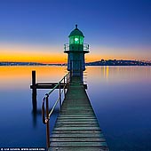
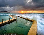
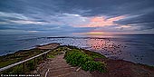
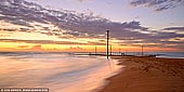
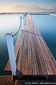
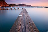
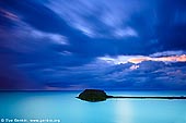
The Narrabeen Beach and the tidal pool on the northern side of the beach are quite popular among Sydney's landscape and seascape photographers. North Narrabeen tidal pool has a unique walkway that goes through the pool itself and provides plenty of opportunities for photographers. The tidal pool is not really sensitive to tides, so you can shoot this pool at any tide. The pool is also back far enough that it doesn't really get impacted by large swells.
Getting to North Narrabeen tidal pool is pretty simple, from Pittwater Rd you can take a right onto Ocean Rd and drive along Narrabeen beach, or you can turn East onto Walsh Rd at Warriewood. There is plenty of parking just North of the lagoon and it is a short 5 min walk along paved roadway to get to the tidal pool. No rock hopping or scrambling involved.
The best time of the day to visit Narrabeen Beach is pre-dawn and sunrise of course. However sunset is also could be quite nice if there are some clouds in the sky. Be sure to check nice North Narrabeen Head lookout as well as it provides very beautiful view of the beach and Narrabeen lagoon.
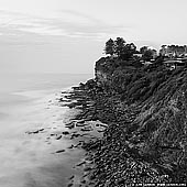
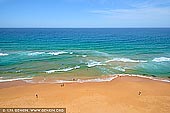
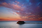
Long Reef Point is located between Dee Why and Collaroy on the Northern Beaches of Sydney, Australia and comprises three protected areas: Long Reef Aquatic Reserve, Long Reef Wildlife Protection Area, and Dee Why Lagoon Wildlife Refuge. It is a popular spot for walkers and provides spectacular views to the north as far as the central coast and the south to Manly. It is approximately 20 kilometres north of the Sydney city and great place to walk around. At low tide you can walk over the rock platform and look in the rock pools. People fly hand gliders and fly model planes from the top. It offers great views up and down the coast.
Long Reef Point is a prominent 36 meters high shale headland that protrudes 2 km seaward, and is surrounded by wide intertidal rock platforms, with reefs extending to the north and south of the point.
There is Long Reef Aquatic Reserve around two main rocky shores. The northern rocky reef area is protected from southerly swells by the prominent eastern headland, while the larger eastern platform is more exposed. Different organisms occur in these two areas. Long Reef Aquatic Reserve protects the marine invertebrates on the rock platforms as well as subtidal marine plants and animals. It is also an important site for marine education.
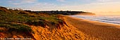
Long Reef Beach is a perfect stretch of white sand. Long Reef-Dee Why Beach extends for 1.8 km from the base of Long Reef Point to Dee Why Point and is backed by 25 ha Dee Why Lagoon. The beach faces the southeast and picks up any east to southeast swell making it one of Sydney's higher energy beaches. The waves average 1.6 m being highest in the south and centre, decreasing north of the Long Reef surf club owing to waves breaking on the outer reefs. Between Long Reef surf club and Dee Why Point are usually eight strong rips, including the particularly hazardous rip that flows out against Dee Why Point. The rips and their feeder currents usually form a continuous trough with currents heading into the rips.
The lookout atop of the hill at the Long Reef Point is a popular Humpback Whale migration watching spot. They are passing Sydney between April and December each year.
Dee Why is a suburb of northern Sydney, in the state of New South Wales, Australia 18 kilometres north-east of the Sydney central business district. It is the administrative centre of the local government area of Warringah Council, and along with Brookvale is considered to be the main centre of the Northern Beaches region.
The origin of the name of neighbouring Long Reef is obvious, but the reasons for Dee Why's name remain unclear. The earliest reference to it is a pencil note in surveyor James Meehan's field book, "Wednesday, 27th Sept, 1815 Dy Beach - Marked a Honey Suckle Tree near the Beach". What it meant to him was not recorded. From 1840 the name was recorded as one word, 'Deewhy', but was split in two during the 1950s. The term 'Dee Why' was also used to name 'Dee Why Heights' or Highlands, known as Narraweena since 1951, and 'Dee Why West', the name of which was changed to Cromer in 1969.
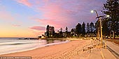
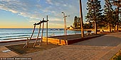
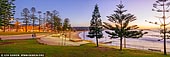
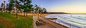
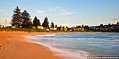
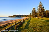
Dee Why Beach runs for about 1.2 km along the eastern border, overlooking the Tasman Sea. To the north are the dunes separating the beach from the Dee Why Lagoon. At its southern end is the Ted Jackson Reserve (renamed from Dee Why Beach Reserve in October 2010), with picnic areas and century old Norfolk Island Pines, similar to the ones in Manly. The reserve is contained by a seawall running for approximately 400m, and was upgraded in 2006, with new pathways, stairs, lookout platforms, an upper promenade and the restoration of the war memorial. There are two playgrounds in the vicinity, located at the southern end of the beach and west of the Dee Why Surf Life Saving Club, near to the lagoon, and several ocean pools located below cliffs to the south. Car parking facilities exist in the streets to the south, as well as a car park next to the Life Saving Club.
Dee Why Beach is not as well known internationally as say Bondi or Manly but this stretch is one of the most popular Sydney's beaches. Over the last few years Dee Why has been tastefully re-developed with a new promenade (or Corso) and apartment blocks. An excellent selection of restaurants and cafes on the beachfront strip adds to the finesse. Dee Why has a cozy family feel and meets the needs and expectations of its residents and welcomed visitors. Dee Why Beach offers gorgeous scenery, great restaurants and bars, awesome surf, spectacular hiking trails, live music, rock pools, modern playgrounds and friendly locals.
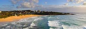
Curl Curl is a suburb of northern Sydney in the state of New South Wales, Australia. Curl Curl is located 18 kilometres north-east of the Sydney central business district, in the local government area of Warringah Council and is part of the Northern Beaches region. Curl Curl is colloquially known as "Curly".
Curl Curl may be derived from the Aboriginal phrase 'curial curial' meaning river of life. Curl Curl Lagoon separates North Curl Curl and Curl Curl. The northern dunes were partly removed during the war and finally returned to a somewhat natural state in the 1980s. North Curl Curl still has a relatively natural appearance.
North Curl Curl is a suburb of the Northern Beaches and is located 19 kilometres north east of the Sydney central business district in the local government area of Warringah Council.
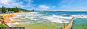
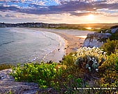
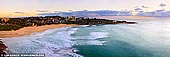
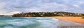
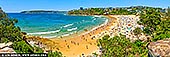
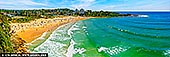
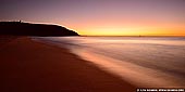
Freshwater Beach is a beach located in Freshwater, New South Wales, a suburb of Sydney, Australia. Freshwater Beach is the first beach north of Manly, New South Wales, on the Peninsula. The beach is flanked by a headland at each end and can produce excellent surf. There is a large rock pool at the northern end. The beach is patrolled by lifeguards and has its own surf lifesaving club. The beach is approximately 300 metres long and around 100 metres wide. It is enclosed by headlands, giving it a private feel. When other beaches are closed due to strong currents or blue bottles, Freshwater Beach is usually open.
The northern part of the beach has its own rock baths, which is a bonus for families when the sea is a bit rough for kids. On calm days, the beach is ideal for snorkelling and most days it has good swell for surfers.
On 10 March 2012, the four kilometre stretch between Freshwater Beach and Shelly Beach was declared the "Manly-Freshwater National and World Surfing Reserve". The Reserve was dedicated in a ceremony at Manly Beach by world surfing champion Kelly Slater accompanied by the Governor of New South Wales, Australia, Professor Marie Bashir. It is recognises the historical, cultural and environmental values of famous surfing beaches. It is where Duke Kahanamoku held his famous 1915 surfing demonstration that popularised surfing in Australia.
Freshwater Beach is good family beach with good swimming conditions and excellent body boarding at the south end. Best with north east wind conditions.
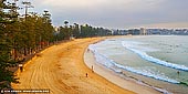
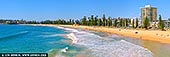
Manly Beach is a beach situated in Sydney's Northern Beaches, Australia. From north to south, the three main sections are Queenscliff, North Steyne, and South Steyne.
Manly is one of Sydney's most popular seaside destinations and is one of Australia's most popular beaches. Full of attractions and exciting activities including Manly Beach, Oceanworld, kayaking, swimming, tennis, golf, beach volleyball, roller blading, scenic and historical walks, art, parasailing, scuba diving, fishing, dining and so much more. Manly is the perfect destination for your next Sydney escape. The prominent icon that symbolises the beaches and the ocean of Manly is the Norfolk Island Pine.
Within walking distance of Manly Beach along the oceanway is Fairy Bower and Shelley Beach. There are shops, restaurants, night clubs, and dive bars in town.
The beach was named by Capt. Arthur Phillip for the indigenous people living there. He wrote about them, "Their confidence and manly behaviour made me give the name of Manly Cove to this place".
Shelly Beach (also sometimes referred as Shelley Beach) is a beach located in the Manly area of Sydney, New South Wales, Australia. It is close to North Head and Fairy Bower.
Fairy Bower is a beach in the Manly area of Sydney, New South Wales, Australia. Fairy Bower is an affluent area, located close to Shelly Beach and North Head. A scenic walk links Manly Beach to Fairy Bower and Shelly Beach.
About the Artist
I'm Ilya Genkin - an internationally recognised Australian landscape and fine art photographer offering wall art prints. My passion for capturing the beauty of nature and our world translates into striking photographic prints that bring life, emotion, and inspiration to any space. From tranquil seascapes to dramatic mountainscapes, each image is a reflection of my vision and dedication to the art of photography.
Read more about Ilya Genkin and shop fine art prints online from his collection.
Wall Art Prints Featuring Fine Art Landscape Photography
Explore my extensive collection of wall art prints - crafted with the highest-quality materials to suit every style and budget. Whether you're looking for a luxurious, ready-to-hang piece or a beautifully printed work to frame yourself, each photograph is available in several premium formats: Gallery-quality Fine Art Paper Prints - ready for framing, and Professional Canvas Prints - classic and timeless texture.
Each artwork is meticulously printed and made-to-order to ensure you receive a piece that elevates your home, office, or commercial space. Buy fine art prints online to suit your style.
Artworks for Interior Designers, Home Stylists, and Architects
I collaborate with interior designers, home stylists, and architects to create bespoke wall art prints tailored to your project's aesthetic, colour palette and interior design needs. Prints can be customised and sized to complement your space perfectly. All pieces are made-to-order, and pricing varies based on size, quantity, and shipping.
Contact me to discuss your project and request a personalised quote.
Why Choose Ilya Genkin Photography?
By choosing my work, you're not just acquiring exceptional art - you're supporting an independent Australian artist and contributing to a vibrant local creative community. Every purchase directly helps sustain and grow this craft, bringing authentic and meaningful art into your life.
Request a free mockup to see how a chosen photograph will look in your space before you buy.
Start your journey today - shop our wall art collection, purchase with confidence, or order custom prints today and transform your walls with fine art photography.
Fine Art Landscape Photography
Information
- FAQ - Landscape Photography Prints
- Purchase Fine Art Prints
- Black and White Fine Art Prints
- Art Consultation for Your Home
- Design Tips for Styling Your Space with Art
- Limited Edition vs Open Edition Prints
- Collector Resources
- FAQ - Image Licensing
- License Stock Photos
- Stock Photo Price Request
- Materials and Sustainability
Photography Guides
Online Store Opens 24/7
Email:
Phone: +61 (0) 421 055 613

Crafted with care for the planet - using sustainable materials and eco-friendly packaging.
Ilya Genkin Photography acknowledges the Traditional Custodians of the land on which we operate, live and gather as employees, and recognise their continuing connection to land, water and community. We pay respect to Elders past, present and emerging.