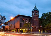
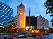
Parramatta
Sydney, NSW, Australia
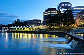
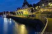
Parramatta is a suburb of Sydney, New South Wales, Australia. It is located in Greater Western Sydney 23 kilometres (14 mi) west of the Sydney central business district on the banks of the Parramatta River.
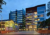
Parramatta is the economic capital of Greater Western Sydney and the sixth largest central business district in Australia. Since 2000, Parramatta has seen the consolidation of its role as a government centre with the relocation of agencies such as the New South Wales Police Force headquarters and Sydney Water, from the Sydney CBD. Simultaneously, major upgrades have occurred around the railway station with the expansion of Westfield Parramatta, the creation of a new transport interchange, and the ongoing development of the Civic Place local government precinct. It is sometimes called as Sydney's Second CBD.
The Darug people had lived in the area for many generations, and regarded the area as rich in food from the river and forests. They called the area Baramada or Burramatta ('Parramatta') which means 'head of waters' or 'the place where the eels lie down'. To this day there is a plenitude of eels and other sea creatures attracted to the profusion of nutrients created by the saltwater of Port Jackson meeting the freshwater of the Parramatta River's catchment. The eel has been adopted as the symbol of the Parramatta Eels Rugby League club.
Parramatta was founded in 1788, the same year as Sydney. The British Colony, which had arrived in January 1788 in the First Fleet at Sydney Cove, had only enough food to support itself for a short time and the soil around Sydney Cove proved too poor to grow the amount of food that 1,000 convicts, soldiers and administrators needed to survive. During 1788, Governor Arthur Phillip had reconnoitred several places before choosing Parramatta as the most likely place for a successful large farm. Parramatta was the furthest navigable point inland on the Parramatta River (i.e. furthest from the thin, sandy coastal soil) and also the point at which the river became freshwater and therefore useful for farming.
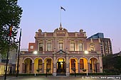
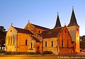
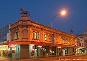
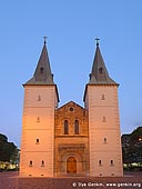
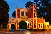
Parramatta has many buildings on the Register of the National Estate, including: Elizabeth Farm House, Experiment Farm Cottage, Lancer Barracks, Parramatta Town Hall, the former Post Office in Church Street, Centennial Clock, Lennox Bridge, St John's Cathedral, St John's Cemetery, St Patrick's Cathedral, Parochial School in Elizabeth Street, Arthur Phillip High School, Brislington in Marsden Street, Hambledon Cottage in Hassall Street, former King's School Group, Roman Catholic Cemetery in North Parramatta, Parramatta Psychiatric Centre (Cumberland Hospial), Parramatta Park � including Old Government House, All Saints Church Group.
About the Artist
I'm Ilya Genkin - an internationally recognised Australian landscape and fine art photographer offering wall art prints. My passion for capturing the beauty of nature and our world translates into striking photographic prints that bring life, emotion, and inspiration to any space. From tranquil seascapes to dramatic mountainscapes, each image is a reflection of my vision and dedication to the art of photography.
Read more about Ilya Genkin and shop fine art prints online from his collection.
Wall Art Prints Featuring Fine Art Landscape Photography
Explore my extensive collection of wall art prints - crafted with the highest-quality materials to suit every style and budget. Whether you're looking for a luxurious, ready-to-hang piece or a beautifully printed work to frame yourself, each photograph is available in several premium formats: Gallery-quality Fine Art Paper Prints - ready for framing, and Professional Canvas Prints - classic and timeless texture.
Each artwork is meticulously printed and made-to-order to ensure you receive a piece that elevates your home, office, or commercial space. Buy fine art prints online to suit your style.
Artworks for Interior Designers, Home Stylists, and Architects
I collaborate with interior designers, home stylists, and architects to create bespoke wall art prints tailored to your project's aesthetic, colour palette and interior design needs. Prints can be customised and sized to complement your space perfectly. All pieces are made-to-order, and pricing varies based on size, quantity, and shipping.
Contact me to discuss your project and request a personalised quote.
Why Choose Ilya Genkin Photography?
By choosing my work, you're not just acquiring exceptional art - you're supporting an independent Australian artist and contributing to a vibrant local creative community. Every purchase directly helps sustain and grow this craft, bringing authentic and meaningful art into your life.
Request a free mockup to see how a chosen photograph will look in your space before you buy.
Start your journey today - shop our wall art collection, purchase with confidence, or order custom prints today and transform your walls with fine art photography.
Fine Art Landscape Photography
Information
- FAQ - Landscape Photography Prints
- Purchase Fine Art Prints
- Black and White Fine Art Prints
- Art Consultation for Your Home
- Design Tips for Styling Your Space with Art
- Limited Edition vs Open Edition Prints
- Collector Resources
- FAQ - Image Licensing
- License Stock Photos
- Stock Photo Price Request
- Materials and Sustainability
Photography Guides
Online Store Opens 24/7
Email:
Phone: +61 (0) 421 055 613

Crafted with care for the planet - using sustainable materials and eco-friendly packaging.
Ilya Genkin Photography acknowledges the Traditional Custodians of the land on which we operate, live and gather as employees, and recognise their continuing connection to land, water and community. We pay respect to Elders past, present and emerging.