New Zealand Mountains
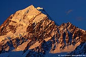
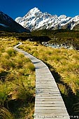
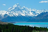
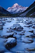
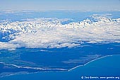
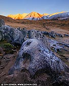
Aoraki / Mount Cook is the highest mountain in New Zealand, reaching a height of 3,754 metres (12,316 ft). It lies in the Southern Alps, the mountain range which runs the length of the South Island. A popular tourist destination, it is also a favourite challenge for mountain climbers. Aoraki / Mount Cook consists of three summits lying slightly south and east of the main divide, the Low Peak, Middle Peak and High Peak, with the Tasman Glacier to the east and the Hooker Glacier to the west. Mount Cook, New Zealand's tallest peak is known as Aoraki by Maori. According to legend, Aoraki was a young boy in the canoe Te Waka a Aoraki, which was stranded on a reef and tilted to one side. Aoraki and his brothers climbed to the high side and sat on the wreckage. The south wind froze them and turned them into stone, creating the Southern Alps/Ka Tiritiri o te Moana. In 1851 Captain J. L. Stokes, sailing down the West Coast, gave the mountain its European name, Mt Cook, in honour of the English navigator Captain James Cook. The Aoraki / Mount Cook Mackenzie region is situated in the centre of New Zealand's majestic South Island. The region is renowned for its incredibly clear starry nights, brilliant sunny days, remarkable turquoise blue lakes, valleys of emerald green and snow-capped mountains. Shaped by the giant forces of nature, massive glaciers have scoured the land leaving a trail of lakes and rivers across the landscape. Aoraki / Mount Cook was formally established as a national park in 1953 from reserves that were established as early as 1887 to protect the area's significant vegetation and landscape. The park is a harsh land of ice and rock. Glaciers cover 40% of it. There are 19 peaks over 3,000 metres including of course New Zealand's highest mountain, Aoraki/Mount Cook. The park is also part of Te Waipounamu - South Westland World Heritage Area in recognition of its outstanding natural values.
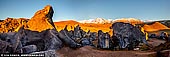
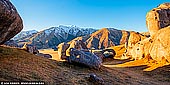
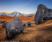
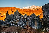
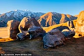
Castle Hill is a location and a high country station in New Zealand's South Island. It is located at an altitude of 700 metres, close to State Highway 73 between Darfield and Arthur's Pass. It is private property and located within the Kura Tawhiti Conservation Area. The hill was so named because of the imposing array of limestone boulders in the area reminiscent of an old, run-down stone castle. The front of Christchurch Cathedral in Christchurch was made from Castle Hill limestone. The station was established by the Porter brothers, and later owned by brothers John and Charles Enys. John Enys was a noted entomologist, and friend of novelist Samuel Butler. It is widely considered to be the epitome of New Zealand's South Island climbing scene, where on any given day one can find rock climbers bouldering the unique limestone outcroppings. This area has recently seen more visitors, as nearby Flock Hill station was used for the filming of the climactic battle scenes of the 2005 movie, The Chronicles of Narnia: The Lion, the Witch and the Wardrobe. Flock Hill also has a huge number of climbable limestone boulders though access requires a short certification procedure via the internet, unlike Kura Tawhiti which, as a conservation area, allows free access at all times.
About the Artist
I'm Ilya Genkin - an internationally recognised Australian landscape and fine art photographer offering wall art prints. My passion for capturing the beauty of nature and our world translates into striking photographic prints that bring life, emotion, and inspiration to any space. From tranquil seascapes to dramatic mountainscapes, each image is a reflection of my vision and dedication to the art of photography.
Read more about Ilya Genkin and shop fine art prints online from his collection.
Wall Art Prints Featuring Fine Art Landscape Photography
Explore my extensive collection of wall art prints - crafted with the highest-quality materials to suit every style and budget. Whether you're looking for a luxurious, ready-to-hang piece or a beautifully printed work to frame yourself, each photograph is available in several premium formats: Gallery-quality Fine Art Paper Prints - ready for framing, and Professional Canvas Prints - classic and timeless texture.
Each artwork is meticulously printed and made-to-order to ensure you receive a piece that elevates your home, office, or commercial space. Buy fine art prints online to suit your style.
Artworks for Interior Designers, Home Stylists, and Architects
I collaborate with interior designers, home stylists, and architects to create bespoke wall art prints tailored to your project's aesthetic, colour palette and interior design needs. Prints can be customised and sized to complement your space perfectly. All pieces are made-to-order, and pricing varies based on size, quantity, and shipping.
Contact me to discuss your project and request a personalised quote.
Why Choose Ilya Genkin Photography?
By choosing my work, you're not just acquiring exceptional art - you're supporting an independent Australian artist and contributing to a vibrant local creative community. Every purchase directly helps sustain and grow this craft, bringing authentic and meaningful art into your life.
Request a free mockup to see how a chosen photograph will look in your space before you buy.
Start your journey today - shop our wall art collection, purchase with confidence, or order custom prints today and transform your walls with fine art photography.
Fine Art Landscape Photography
Information
- FAQ - Landscape Photography Prints
- Purchase Fine Art Prints
- Black and White Fine Art Prints
- Art Consultation for Your Home
- Design Tips for Styling Your Space with Art
- Limited Edition vs Open Edition Prints
- Collector Resources
- FAQ - Image Licensing
- License Stock Photos
- Stock Photo Price Request
- Materials and Sustainability
Photography Guides
Online Store Opens 24/7
Email:
Phone: +61 (0) 421 055 613

Crafted with care for the planet - using sustainable materials and eco-friendly packaging.
Ilya Genkin Photography acknowledges the Traditional Custodians of the land on which we operate, live and gather as employees, and recognise their continuing connection to land, water and community. We pay respect to Elders past, present and emerging.