Murray River
New South Wales, Victoria and South Australia
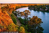
The Murray River is Australia's longest river. At 2,375 kilometres (1,476 mi) in length, the Murray rises in the Australian Alps, draining the western side of Australia's highest mountains and, for most of its length, meanders across Australia's inland plains, forming the border between New South Wales and Victoria as it flows to the northwest, before turning south for its final 500 kilometres (310 mi) or so into South Australia, reaching the ocean at Lake Alexandrina.
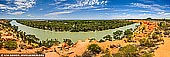
There are two tourism regions around South Australia's Murray River: Murraylands and Riverland. They stretch from Wellington in the west to Paringa in the east and cover landscapes of spectacular river and mallee scenery. Driving from the eastern states, it's only one and half hours from Mildura. The Murraylands incorporates the vast Murray Mallee farming region to the east of the River Murray, reaching right to the Victorian border and sprawling south to the Dukes Highway. The Riverland's restored paddle steamers, museums and villages recapture the history of the River Murray. Wetlands and billabongs teem with wildlife. Parks and reserves offer good walking trails and a range of facilities on site.
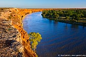
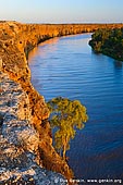
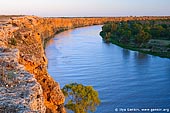
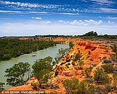
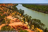
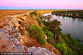
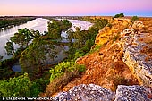
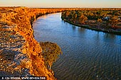
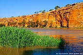
Big Bend in South Australia is the longest single bend in the Murray River. It's located in about 9km from from Swan Reach. The area is known for its spectacular riverside cliffs, which are the tallest along the Murray River. The limestone cliffs are rich with millions of ocean fossils and are home to colonies of bats. Caves in the area have been continuously occupied for at least 8,000 years and are sacred to the local aboriginal community. There is a collection of holiday shacks located on the banks. The Big Bend is also a favourite spot for artists and photographers.
About the Artist
I'm Ilya Genkin - an internationally recognised Australian landscape and fine art photographer offering wall art prints. My passion for capturing the beauty of nature and our world translates into striking photographic prints that bring life, emotion, and inspiration to any space. From tranquil seascapes to dramatic mountainscapes, each image is a reflection of my vision and dedication to the art of photography.
Read more about Ilya Genkin and shop fine art prints online from his collection.
Wall Art Prints Featuring Fine Art Landscape Photography
Explore my extensive collection of wall art prints - crafted with the highest-quality materials to suit every style and budget. Whether you're looking for a luxurious, ready-to-hang piece or a beautifully printed work to frame yourself, each photograph is available in several premium formats: Gallery-quality Fine Art Paper Prints - ready for framing, and Professional Canvas Prints - classic and timeless texture.
Each artwork is meticulously printed and made-to-order to ensure you receive a piece that elevates your home, office, or commercial space. Buy fine art prints online to suit your style.
Artworks for Interior Designers, Home Stylists, and Architects
I collaborate with interior designers, home stylists, and architects to create bespoke wall art prints tailored to your project's aesthetic, colour palette and interior design needs. Prints can be customised and sized to complement your space perfectly. All pieces are made-to-order, and pricing varies based on size, quantity, and shipping.
Contact me to discuss your project and request a personalised quote.
Why Choose Ilya Genkin Photography?
By choosing my work, you're not just acquiring exceptional art - you're supporting an independent Australian artist and contributing to a vibrant local creative community. Every purchase directly helps sustain and grow this craft, bringing authentic and meaningful art into your life.
Request a free mockup to see how a chosen photograph will look in your space before you buy.
Start your journey today - shop our wall art collection, purchase with confidence, or order custom prints today and transform your walls with fine art photography.
Fine Art Landscape Photography
Information
- FAQ - Landscape Photography Prints
- Purchase Fine Art Prints
- Black and White Fine Art Prints
- Art Consultation for Your Home
- Design Tips for Styling Your Space with Art
- Limited Edition vs Open Edition Prints
- Collector Resources
- FAQ - Image Licensing
- License Stock Photos
- Stock Photo Price Request
- Materials and Sustainability
Photography Guides
Online Store Opens 24/7
Email:
Phone: +61 (0) 421 055 613

Crafted with care for the planet - using sustainable materials and eco-friendly packaging.
Ilya Genkin Photography acknowledges the Traditional Custodians of the land on which we operate, live and gather as employees, and recognise their continuing connection to land, water and community. We pay respect to Elders past, present and emerging.