Cape Woolamai
Phillip Island, Victoria (VIC), Australia
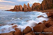
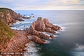
Cape Woolamai is located at the south-eastern tip of Phillip Island in Victoria, Australia, just a few kilometres from Newhaven. The cape was named by George Bass (but spelt "Wollamai") when he passed it on his whaleboat voyage in early 1798. Wollamai is the snapper fish (Pagrus auratus) in the language of the Eora aboriginal people of Port Jackson, where the fish is found. Bass, who had learnt some of the Sydney language from the Eora leader Bennelong,) thought the headland resembled the head of that fish.
A surf beach lines the western coastline of Cape Woolamai which is quite popular with surfers. The northernmost part of this beach, at the end of Lantana Road, is known as The Colonnades and features basalt rock cliff faces which have been weathered by the ocean to create a geological feature resembling organ pipes. Further south is the wide expanse of sand known as Anzacs Beach which is accessed via Woolamai Beach Road. One kilometre further south, at the end of that road, is Phillip Island's only surf lifesaving club where there is a large car park and kiosk. Continuing southwards is Magic Lands Beach which is backed by steep cliffs, and the fascinating rock formation of The Pinnacles is located near the end of the cape.
The headland contains remnant vegetation and wildlife such as an important breeding colony of the Short-tailed Shearwater or Australian Muttonbird. Volunteer groups such as the Cape Woolamai Coast Action Group conduct regular improvement and maintenance works including weed control and revegetation. It lies within the Phillip Island Important Bird Area, so identified by BirdLife International because of its importance in supporting significant populations of Little Penguins, Short-tailed Shearwaters and Pacific Gulls.
About the Artist
I'm Ilya Genkin - an internationally recognised Australian landscape and fine art photographer offering wall art prints. My passion for capturing the beauty of nature and our world translates into striking photographic prints that bring life, emotion, and inspiration to any space. From tranquil seascapes to dramatic mountainscapes, each image is a reflection of my vision and dedication to the art of photography.
Read more about Ilya Genkin and shop fine art prints online from his collection.
Wall Art Prints Featuring Fine Art Landscape Photography
Explore my extensive collection of wall art prints - crafted with the highest-quality materials to suit every style and budget. Whether you're looking for a luxurious, ready-to-hang piece or a beautifully printed work to frame yourself, each photograph is available in several premium formats: Gallery-quality Fine Art Paper Prints - ready for framing, and Professional Canvas Prints - classic and timeless texture.
Each artwork is meticulously printed and made-to-order to ensure you receive a piece that elevates your home, office, or commercial space. Buy fine art prints online to suit your style.
Artworks for Interior Designers, Home Stylists, and Architects
I collaborate with interior designers, home stylists, and architects to create bespoke wall art prints tailored to your project's aesthetic, colour palette and interior design needs. Prints can be customised and sized to complement your space perfectly. All pieces are made-to-order, and pricing varies based on size, quantity, and shipping.
Contact me to discuss your project and request a personalised quote.
Why Choose Ilya Genkin Photography?
By choosing my work, you're not just acquiring exceptional art - you're supporting an independent Australian artist and contributing to a vibrant local creative community. Every purchase directly helps sustain and grow this craft, bringing authentic and meaningful art into your life.
Request a free mockup to see how a chosen photograph will look in your space before you buy.
Start your journey today - shop our wall art collection, purchase with confidence, or order custom prints today and transform your walls with fine art photography.
Fine Art Landscape Photography
Information
- FAQ - Landscape Photography Prints
- Purchase Fine Art Prints
- Black and White Fine Art Prints
- Art Consultation for Your Home
- Design Tips for Styling Your Space with Art
- Limited Edition vs Open Edition Prints
- Collector Resources
- FAQ - Image Licensing
- License Stock Photos
- Stock Photo Price Request
- Materials and Sustainability
Photography Guides
Online Store Opens 24/7
Email:
Phone: +61 (0) 421 055 613

Crafted with care for the planet - using sustainable materials and eco-friendly packaging.
Ilya Genkin Photography acknowledges the Traditional Custodians of the land on which we operate, live and gather as employees, and recognise their continuing connection to land, water and community. We pay respect to Elders past, present and emerging.